Showing posts with label travel. Show all posts

Monday, April 27, 2026

Oklahoma and No Man's Land

Have you ever wondered why Oklahoma has a panhandle?  Why is it called No Man's Land?  Why isn't it part of Texas? Why does the southern border of the panhandle align with the southern border of Missouri, Kentucky and Virginia? 


The panhandle of Oklahoma was not always part of Oklahoma.  It started it's journey to become part of the 46th state when Napoleon Bonaparte sold the land that comprised the Mississippi River drainage west of the river to the United States in 1803.


In 1819, the Adams-Onis treaty ceded the panhandle and other territory to Spain in exchange for Florida.  The panhandle lies between the Arkansas River and Red River and the 100 degree W meridian is its eastern boundary.


At the start of 1820 there were 22 states in the Union, 11 free states and 11 slave states.  When Missouri applied for statehood it created a crisis since it would break the balance of free vs. slave states.  As a solution Maine was added as a free state, restoring the balance.  Additionally, the parallel at 36 degrees 30 minutes north latitude became the the divide between new slave states and new free states created from the Louisiana Purchase territory. This parallel was an extension of the southern border of Kentucky and Virginia.

After the Louisiana Purchase, the US viewed the land west of the Mississippi as a place to relocate Indians from the eastern United States.  After Louisiana and Missouri became states and Arkansas became a territory, that area shrunk. 

In 1830 Andrew Jackson pushed through Congress and signed the Indian Removal Act.  This formalized the unofficial policy of relocation and accelerated the rate at which tribes were pushed out of their homeland and moved to what is now Oklahoma and Kansas. From 1830 to 1841 more than 60,000 native Americans were forced to walk from their homelands to the Indian Territory.


In 1836 the Republic of Texas was established by settlers from the US.  It was an independent nation, recognized by the US but not by Mexico.  Mexico did not inhabit this part of their territory so when folks like Steve Austin, Davey Crocket and Sam Houston established settlements, they effectively controlled the eastern part of what is today Texas.  Additionally they claimed, but did not control additional territory to the west.

In 1845 Texas was admitted to the union as a slave state with the same boundaries as the Republic of Texas.  This created another crisis  because a portion of Texas, including the Oklahoma panhandle, was above the 36 degree, 30 minute line.


In 1850 Texas was in a lot of debt after operating as an independent country and fighting in the Mexican American War.  As part of the compromise to admit California as the 31st state, the US assumed Texas' $10M debt and Texas had to give up some western and northern territory.  This established the borders of Texas as they are today and made the panhandle part of unorganized federal territory.


In 1854 the Kansas-Nebraska Act created the Kansas Territory and Nebraska Territory.  This established the southern border of Kansas at 37 degrees north latitude. As more people moved to the Kansas and Nebraska Territories, the Indians were forced out and relocated to the remaining unorganized territory. 


By 1879 many Indian Tribes were living in Indian Territory, each governing their own portion of the territory. No Man's Land remained unaffiliated with any organized territory or state.


The Dawes Act in 1887 and later the Burke Act and the Curtis Act phased out Indian ownership of land by 1906, and abolished all tribal courts, giving the US government exclusive jurisdiction.

The 1890 Oklahoma Organic Act created the Oklahoma Territory.  Under this law, Indian Territory was subject to the laws of Arkansas and Oklahoma Territory was subject to the laws of Nebraska. 

The new Oklahoma Territory included No Man's Land, ending its 40 year run as an ungoverned strip of land. 

Seeing the writing on the wall, the tribes of the Indian Territory proposed a State of Sequoyah as a new state in 1905. This was rejected by the US Congresss.


The Enabling Act of 1906 allowed the people living in both Oklahoma Territory and Indian Territory to apply for statehood as a single state.

In 1907, Oklahoma was admitted to the union as the 46th State. 

In 1934 the Indian Reorganization Act halted the policies of the Dawes Act and started rebuilding reservations.

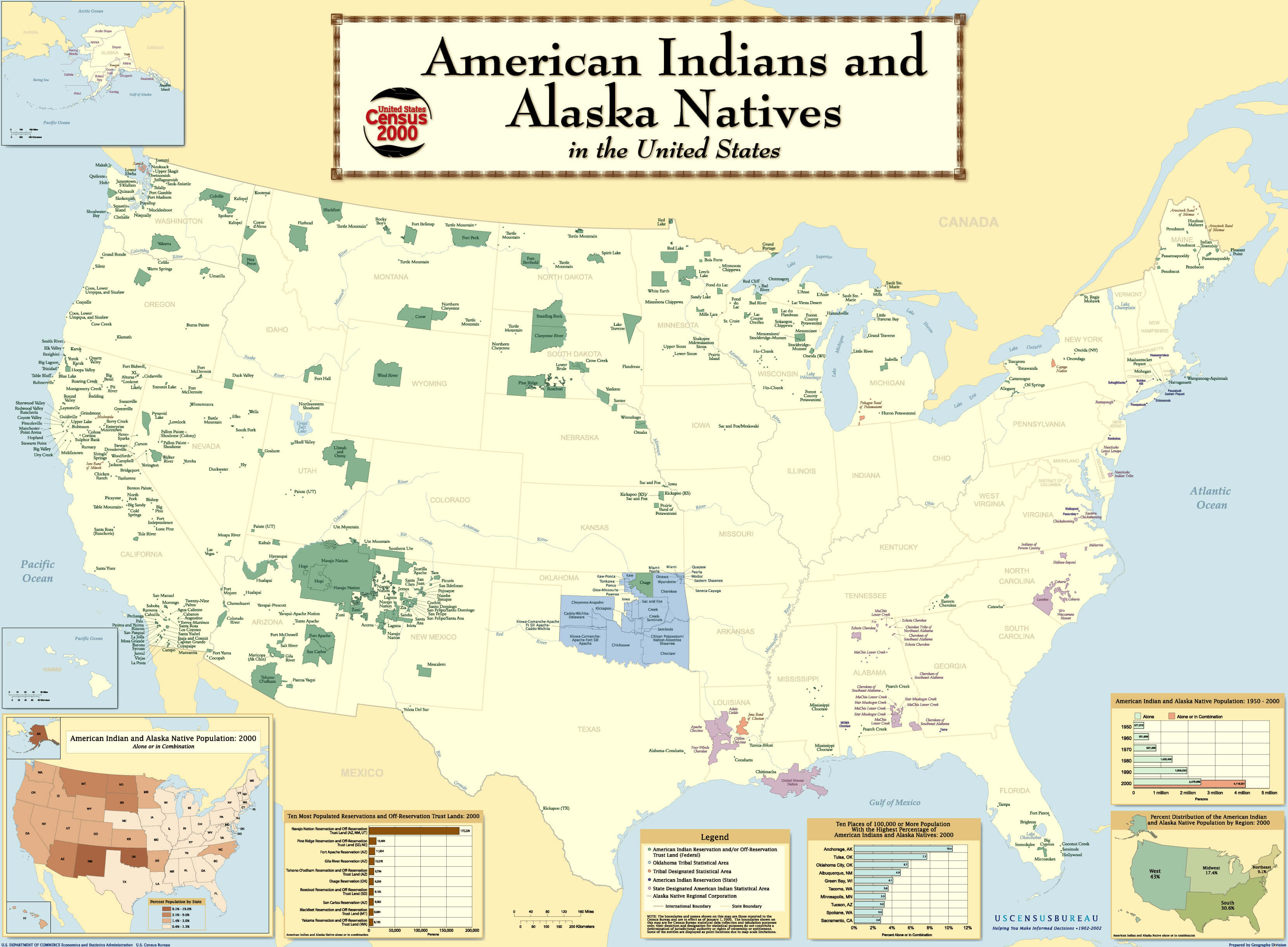
Here is a map of the current (as of 2002) state of Indian Reservation. (click to enlarge)


Monday, August 19, 2024

Onion Valley to South Lake 2024

Aren and I spent 7 days hiking in the Sierra Nevada. We started at the Kearsarge Pass Trailhead near the town of Independence and ended at the Bishop Pass Trailhead near the town of Bishop. We hiked 58 miles (95 km) and climbed 14,200 ft (4,300 m).

Map of our route: https://caltopo.com/m/4KHRS

Elevation Profile of our route:


We stayed at the Mt. Williamson Motel the night before we started. They offer a shuttle service to get us to the trailhead. The service was great but we forgot our hiking poles in the truck and I rode back down and ended up parking the truck at the trailhead. This would become a problem for future me.


The peak on the left is Mt. Williamson, the second highest peak in the lower 48 after Mt. Whitney.


Day 1 in the Eastern Sierra is always challenging. The trails all cross the Sierra Crest, the highest part of the Sierras, which slope up from west to east. From the trailhead at 9,200 ft (2,790 m) we crossed Kearsarge Pass at 11,800 ft (3,580 m) and descended to the Kearsarge Lakes at 10,900 ft (3,300 m), where we camped for the night.

Kearsarge Pass Trailhead in Onion Valley.


Aren and I on top of Kearsarge Pass. Kearsarge Lakes closer to us and Bullfrog Lake furthest from us.


Morning over Kearsarge Lakes


Day 2 we hiked 8.2 miles (5.0 km) on the JMT over Glen Pass (11,926 ft (3,635 m)). Glen Pass is elusive, staying hidden from view until you are less than a mile from the top. This plays tricks with your mind if you are not prepared for it. The descent from Glen Pass to the Rae Lakes is long and steep. We stopped at the lowest of the three lakes at about 10,500 ft (3,180 m) and enjoyed a campsite under a tree.

"If you see a bear, chase it like you are going to catch it and eat it."


Charlotte Dome


Glen Pass from Upper Glen Lake (my name, not official). There are people on the pass if you look closely.


Aren and me on Glen Pass. Rae Lakes behind us.


Glen Pass and Painted Lady seen from our campsite.


Fin Dome seen from our campsite.


An early morning visitor.


Our tent.


Day 3 we hiked down to Woods Creek 8,500 ft (2,580 m) and then followed Woods Creek up toward Mount Cedric Wright. The suspension bridge crossing Woods Creek can get a bit shaky. I tried to cross with no hands, holding my hiking sticks in one hand and filming with the other. I made it about halfway before I freed up one hand to continue. Aren had no trouble. The hike up toward Pinchot Pass climbs 3590 ft (1,090 m).

The trail down to Woods Creek.


Avalanches destroyed trees and obscured the trail in several places.


Woods Creek cascade.


The unlabeled waterfall below the labeled waterfall.


Mount Cedric Wright comes into view at about 9,600 ft (2,910 m) and is prominent until you cross Pinchot Pass.


We camped at 9,800 ft (2,970 m) along Woods Creek just below Mount Cedric Wright


Day 4 we continued along the JMT over Pinchot Pass 12,090 feet (3,685 m) and down to the South Fork of the American River 10,100 ft (3,060 m).

The way up to Pinchot Pass.


Pinchot Pass also stays hidden until you are very close. The trail wends around a ridge and then the crossing comes into view.


The view from Pinchot Pass looking north at Lake Marjorie

We camped at the S Fork of the American River. A squirrel (or similar) chewed up one of Aren's socks.


Day 5 was also on the JMT, up and over Mather Pass (12,068 ft (3,678 m)) and down to lower Palisade Lake (10,600 ft (3,210 m)).

Mather Pass is north of Upper Basin, one of the more spectacular places along the JMT. Upper Basin is home to Split Mountain and Frozen Lake Pass (the gateway to Lake Basin). It is an alpine tundra.


Aren in Upper Basin.


Frozen Lake Pass. Perhaps next year we will cross this Sierra High Route obstacle.


Mount Prater (left) and Split Mountain (right)


Mather Pass does not hide itself, unlike Glen and Pinchot.


Mather Pass. A person circled in red.


Aren and I on Mather Pass with the Palisades Mountains and Palisade Lakes behind us.


Aren pointing up toward Cirque Pass from Lower Palisade Lake. Our first obstacle for the next day.


Day 6 we left the JMT and climbed over Cirque Pass into the Palisade Basin. This was much slower travel and the elevation gains/losses were not as dramatic, but every mile was hard earned.

Aren works his way up to Cirque Pass.


At the top of Cirque Pass looking into Palisade Basin with Potluck Pass (our next obstacle) on the horizon.


Toward the top of Potluck Pass, Aren scrambles up some class 3 rock formations.


From Potluck Pass looking west to Knapsack Pass. The high peak is Columbine. The large black peak to the left of Columbine is the Black Giant. This basin is what I first saw in 2011 when I took my first trip to Dusy Basin and hiked over Knapsack Pass. This time we are approaching it from the other direction, but it is still just as awe inspiring.


View of Knapsack Pass from our campsite at the outlet of Upper Barrett Lake.


Camping in Palisade Basin under North Palisade.


Day 7 saw us cross Knapsack Pass and work our way through Dusy Basin without losing too much elevation. We crossed Bishop Pass and made our way down the trail to South Lake. At South Lake we had another problem, no public transportation and no car parked there for us. Fortunately a Bishop local took pity on us and gave us a ride into town. We stayed the night at a motel and arranged a ride with a local trailhead shuttle driver to take us to Onion Valley in the morning.

The final approach to Knapsack Pass.


I took this same picture in of North Palisade in 2011 at the top of Knapsack Pass and have been using it as the image on my credit card since then. Aren found the spot I took the original from.


Sometimes the rocks just create easy ramps to walk down.


Making our way to Bishop Pass, we had to traverse to avoid losing (and having to regain) hundreds of feet of elevation.


The final high point of the trip, Bishop Pass (11,972 ft (3,630 m)). It was really windy.


The rest of the trip down was uneventful and despite walking through some beautiful country, we were in a rush to get a ride and didn't stop to take any pictures. After a couple of trips that had to be cut short, this was finally a trip that we were able to complete as planned. We traversed the heart of the JMT and one segment of the SHR. We were tired but both agreed that it was time and effort well spent.

We waited at the trailhead for people to exit and asked several for a ride.  Being two guys, we did not ask any single ladies or women with children.  Nonetheless a local woman who recognized us as stranded hikers took pity on us and gave us a ride to Bishop.  We stayed the night in a motel and arranged for a private shuttle to drive us to our car the next day.